Introduction of cultural assets
Preface
Setouchi Town is an administrative region that consists of the southern
part of the main Amami island together with the islands of Kakeroma, Uke,
and Yoro. The suffix shima or jima (meaning "island" in Japanese)
is very often included as part of an island's names, and so these three
islands are usually referred to as Kakeroma-jima, Uke-shima, and Yoro-shima.
Interestingly (but often confusingly), a village in Amami is also locally
referred to as a being a "shima". There are 56 such village shima
in Setouchi, all of which are situated close to the sea.
This booklet is a reduced version added to an English translation of "Bunkazai wo Tazunete (The Cultural Properties of Setouchi town)".
English and Japanese sometimes do not match because the required contents are different between Japanese and other languages.
This booklet provides a general introduction to The "Designated Cultural
Assets" (as determined by the national government) of Setouchi, although
some attention will be given to other historical, cultural and natural
features of the area wherever space allows.
- Location:
450m south from Kagoshima city. 28.8km from east to west. 27.8km from north
to south.
- Total area:
239km2
- Total forest area:
210km2
- Latitude:
28〜28゚15’north
- Longitude:
129゚8’〜26’east
The geological features: It is comprised the Paleozoic strata whole area.
The geological classification contains mainly sandstone, clay rock, green
tuff, and limestone.
The longest river: 5.5 km of Aginagawa
The highest mountain: Yuidake
The deepest point in the sea: 70 m
Population: 9983
Origine of name “Setouchi town”
 Setouchi town contains some regions and Islands, the southern Amami, Kakeroma,
Uke, Yoro.
What is the Origine of name “Setouchi” meaning the inland sea in Japanese. Many Japanese would think that this origine of name is the Inland Sea between Hiroshima and Shikoku District. No wander they think so. Because the lee of islands, or the calm sea, Setouchi’s scenes are very much like there.
This name “Setouchi” was born by the merger of Koniya town and Nishikata village and Saneku village and Chinzei village in 1956. No one opposed this name, because all of this area has been called “Setouchi” for a long time.
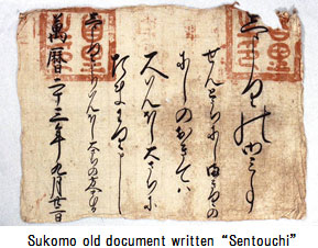
An ancient document written this naming remains in Kakeroma’s Sukomo. According this document, a place name “Sentouchi” was written in hiragana in 1595, during under control of Ryukyu Kingdom. It would be the oldest record currently about this naming.
Our town name “Setouchi” doesn’t originate from “the Inland Sea”. Maybe, people would be calling “Setouchi” or “Sentouchi” for the calm sea in erstwhile Japan or Ryukyu.
“Setouchi town” is a name of old and new.
Once upon a time
 Koniya is in southern end of Route 58. It is the largest city now in Setouchi, but it was just small village of 339 people until around 1870. After that, Koniya grew gradually bigger as a center for the southern Amami politics or economy or transportation by ship, and developed rapidly by placing Japanese army base in 1920. Koniya population had been grown to 4732 ahead of Shodon 1023 and Yoro 1050 in 1940.
But after war, the population decline continued because to make the coming and going possible to another city in Japan after return from America.
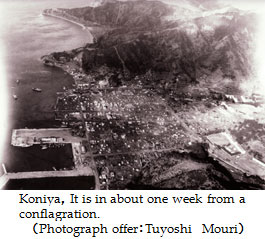
There was a big fire, Koniya was burnt down in 1958. This big fire was the biggest in Kagoshima after war, but no one has died.
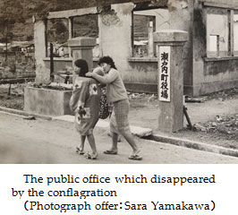 This Koniya is a city that revived through two soil burning of war and a big fire.
A brief history of Yadori Beach
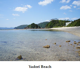 Twenty minutes by car from Koniya, Yadori Beach is well-known for its excellent
swimming. In Japanese, the word “yadori” means "hut" or "small
dwelling place" (often temporary). With a critical scarcity of flat
land in southern Amami, people were forced to use small patches of level
ground in mountains or in other distant places for growing sugarcane, their
main crop. "Yadori" were commonly built in such locations as
places to live in during the seasons of harvest and sugar manufacture.
Perhaps this isolated beach was named after the yadori that may have been
built on it.The Marine Station Amami Hotel now stands on Yadori Beach,
but this area was a swampy, wet place in the past. Except for what was
once the deepest part of the swamp, this area has now been reclaimed. For
a short period after the war, sugar cane, watermelon, peanuts and other
crops were grown in the area, and until around 1955 a yadori (used for
cooking) stood on the beach below the hotel.Yadori Beach is located on
the Kaitsuzaki peninsula. Taken over by the Japanese army for building
military facilities in 1920, the peninsula was sold back to the local people
after the war. Sokaru village only had enough money to buy the Yadori Beach
side; other village bought the rest.On the right hand side of Yadori beach,
as you look out to sea, there is a small island. People call it “Hinjabana”,
which means “goat muzzle”. Flocks of goats would cross there at low tide,
and at high tide people used small traditional boats, called “itatsuke”,
to reach the island.
A Brief History of the Honohoshi coast
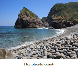 The Honohoshi coast boasts a rare pebble beach, and it has for this reason become a popular sightseeing location. Large waves coming in from the Pacific Ocean break upon the beach with a sound that the locals transliterate as "karakoro". The Honohoshi coast is located on the isthmus that connects the Kaizuzaki peninsula to mainland Setouchi. When boats were an important means of local transport, people often saved themselves the time-consuming and sometimes dangerous trip around the peninsula by lugging their boat across land at this point. In fact the name "Honohoshi" derives from this practice―the word "funakoshi" means "boat taken overland".The name "Honohoshi" is also used in the settlement of Uken (part of Uken Village), and in Tebiro (Tatsugo Town). In both locations the name similarly refers to a land-crossing for boats. The isthmus on the opposite side from Honohoshi is called "Urasoko". In the 1920s the Japanese army created a pond there, as part of its road construction activities. This pond is now utilized as a prawn farm. The beach at Honohoshi is separated into two parts by a large rock called "Kuradi". The beach on the left-hand side is called"Uranokoshi", and the beach on the right-hand side is called "Ufuchiburi". A monument to Sakae Osugi-a prominent leftist leader and the foremost Japanese anarchist of the Taisho Period (1921-26)-was constructed on the top of this rock. The statue caused an uproar.
Kouchiyama
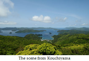 From the lookout at the top of the mountain "Kouchiyama" a superb view of the whole of the Setouchi area can be had.
The origin of the name "Kouchiyama" is unknown. One opinion is that a frequently used name for a mountain in Amami, "Takabachiyama", was first transliterated into kanji (non-phonetic Japanese characters), with an alternate reading for these characters then coming into widespread use.During the Second World War, the regional base for the Japanese defence force was in Koniya. But when the war situation worsened, the army was moved to Tokunoshima and the navy to Kikaijima, where runways were then constructed. What remained of the Koniya base was relocated to somewhere near Kouchiyama. The exact place is unknown, but it is likely to have been near the present scenic observatory.
Seaside trees of Deigo
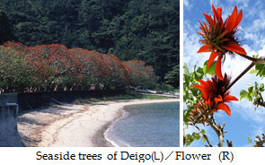 Deigos, ancient trees said to be three hundred years old, line the shore
along Shodon in Kakeroma Island. Deigos have deep red, brightly-colored
flowers during mid May to early July. According the folklore of Shodon,
a long time ago,trading Ryukyu junk ships used the red deigo flowers as
a landmark for Amami. In 2008, the Erythrina Gall Wasps was confirmed on
Amami. These wasps can severely damage deigos, so the people of Amami were
forced to take prompt measures.
|